Lakes Environmental Newsletter
News header

NEWS & EVENTS

Monthly Newsletter - February 2020 Edition

CALPUFF View Version 9.0 Released

toronto Header

Last week, we released CALPUFF View Version 9.0. This release includes the following updates:

  • New Models: Support for the new BETA Version 7.3 models including CALPUFF (7.3.2), CALPOST (7.2.0), POSTUTIL (7.1.0), & CALSUM (7.1.0).
  • New Spray Source: CALPUFF 7.3.2 includes a new source type for analyzing agricultural spraying activities.
  • Shapefile Land Use Support: Land use data in Shapefile format can now be input to the Land Use Creator to generate data compatible with CALPUFF's geophysical processing utilities.
  • Surface Met QA Spreadsheet: A new quality assurance spreadsheet details missing surface meteorological data variables to aid modelers in building complete datasets.

Check out our latest release notes for a detailed listing of CALPUFF View updates.


If you are currently in maintenance for CALPUFF View and did not receive an email regarding this update, please contact us at support@webLakes.com.


If you are a user of CALPUFF View but are no longer in maintenance, please contact our sales team at sales@webLakes.com for pricing to update your software and be eligible for this important new release.

ZEBU at RSA Conference in San Francisco – Feb 24-28, 2020

training header

Zebu will be in San Francisco from February 24 – 28, 2020 for the annual RSA Conference. Joining the top cyber security leaders and a dedicated community of peers as we exchange the biggest and boldest ideas that will help propel the security industry forward.


As existing Lakes Environmental Software customers, please drop by the Ontario Pavilion to meet our knowledgeable team and learn about Zebu’s secure business platform and how it can secure you and your clients sensitive environmental data.

AERMOD Course in Toronto, Canada – Mar 5-6, 2020 - A Few Spots Left!

training header

Our team will present a 2-day AERMOD course in Toronto from March 5-6, 2020.


This course will feature important details about changes to the approved versions of AERMOD & AERMET under Ontario Regulation 419/05 scheduled for implementation in April 2020.


Training will also include a special case study regarding the dispersion modeling requirements of Ontario Regulation 419/05: Air Pollution - Local Air Quality as well as a do-it-yourself WRF case study for each student’s desired location.


Course:

AERMOD (Mar 5-6, 2020)


Location:

Toronto, Ontario

Register

Contact:

training@webLakes.com

AERMOD and CALPUFF Courses in Las Vegas, Nevada – April 20-23, 2020

training header

Our senior subject matter experts will be in Las Vegas to present 4 days of AERMOD and CALPUFF training from April 20-23, 2020.


Both courses will include a WRF case study for each student’s desired location and the CALPUFF portion of this course will also include a special Class I Area Visibility case study.


Course:

AERMOD (Apr 20-21, 2020)


Course:

CALPUFF (Apr 22-23, 2020)


10% Discount Ends:

March 6, 2020


Location:

Las Vegas, Nevada

Register

Contact:

training@webLakes.com

Additional 2020 Course Locations Announced

training header

We’re pleased to announce additions to our 2020 Global Air Dispersion Modeling Course Schedule!


Course dates and locations for the first half of the year are listed below and can also be found by visiting our website. Join us for world class training with our team of senior air quality experts!


Jul 20-23

Lima, Peru


Oct 5-6

Denver, Colorado


Oct 19-22

Dubai, UAE

Schedule

Nov 2-5

Miami, Florida


Online registration will open soon! Start making plans now to attend one of these courses. Early registration discounts will be available for a limited time only!

New Solution from Lakes Software

Are you exposing your client's confidential information? Sending your secrets by post cards is safer than sending by e-mail!


Don't be charged with negligence. Try Zebu today!


Zebu Feature Ad


Install Free Now

UPCOMING COURSES

2020 Course Schedule

AERMOD
March 5-6, 2020 | Toronto, ON
Register →

AERMOD and CALPUFF
April 20-23, 2020 | Las Vegas, NV
Register →

AIR-299 AERMOD and AIR-262 PUFF
June 28-29, 2020 | San Francisco, CA
Register →

AERMOD-CALPUFF
July 20-23, 2020 | Lima, Peru
Register →

AERMOD
October 5-6, 2020 | Denver, CO
Registration Coming Soon

AERMOD-CALPUFF
October 19-22, 2020 | Dubai, UAE
Registrtion Coming Soon

AERMOD and CALPUFF
November 2-5, 2020 | Miami, FL
Registration Coming Soon

aqmis ad

MODELING TIP

Mapping Land Use Data in Shapefile Format

Land use data is vital to air quality modeling because the types of land cover encountered within the modeling domain play a big role in calculating atmospheric stability. Turbulence parameterization will be very different in a heavily populated urban area compared to a flat, grassy field or a large body of water. Digital land use data is available in a wide variety of formats, and the new CALPUFF View Version 9.0 now allows users to import land use data in shapefile format.

The CALPUFF modeling system’s geophysical processors for handling land use data – CTGCOMP and CTGPROC – can only read specific formats such as USGS Composite Theme Grid (CTG), National Land Cover Database (NLCD), and Generic ASCII. Lakes Environmental added the Land Use Creator utility to CALPUFF View many years ago. This utility allows modelers to generate their own land use maps in one of the model-supported formats.

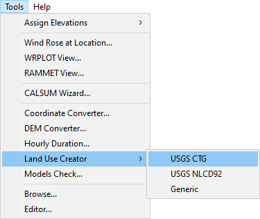
Step 1: In your CALPUFF View project, open the Tools menu and expand the Land Use Creator selection. Choose from USGS CTG, USGS NLCD 1992 GeoTIFF, and Generic formats.

Modeling Tip picture

Step 2: Use the Import | Land Use Data menu option or select the Modeling Tip picture   button.

Step 3: In the Import Land Use File dialog, point to the location of your shapefile. The file used in this example comes from Canadian Land Cover, Circa 2000 GeoBase Series dataset.

Step 4: The Shapefile Land Use Data dialog will appear. This is where the shapefile attributes will be mapped to the selected land use file categories.

Modeling Tip picture

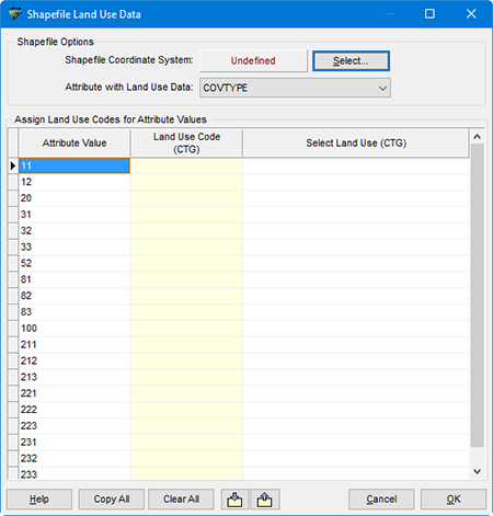
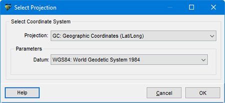
Step 5: Start by defining the Shapefile Coordinate System. The shapefile in this example uses geographic (latitude / longitude) coordinates.

Modeling Tip picture

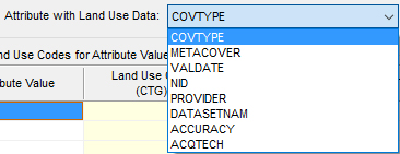
Step 6: Next, identify the shapefile attribute which contains the land use data. This shapefile has an attribute named COVTYPE to identify different land cover types. Make sure to carefully check your shapefile documentation to locate this information.

Modeling Tip picture

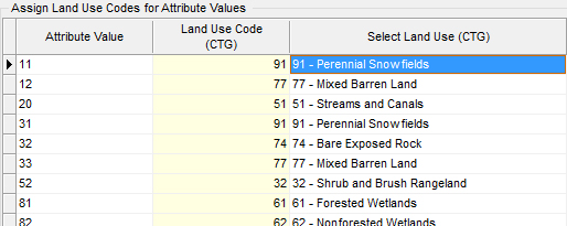
Step 7: Fill in the table to assign a format-specific Land Use Code to each attribute value. Data can be imported from or exported to CSV to make an easy template for adding this information. You can also select categories from the drop-down menu in the Select Land Use column of each row.

Modeling Tip picture

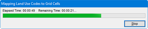
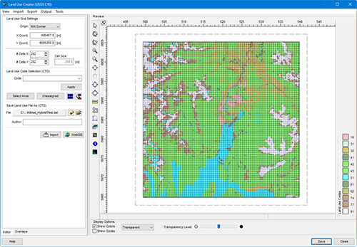
Step 8: Click OK to begin importing the data. The time needed to map the categories will depend on the resolution of the Land Use Creator.

Modeling Tip picture

Step 9: If areas need to be updated or modified, you can use the tools in the Land Use Creator to select cells and Apply different Land Use Codes.

Step 10: Use the Save Land Use File As field to assign a name to your new land use data file.

Step 11: Select the Modeling Tip picture   button to save the file. Click Close to leave the Land Use Creator.

Modeling Tip picture

If multiple shapefiles are needed to cover your full modeling domain, repeat the import process with additional tiles until the entire area is covered.

Once the file has been created, you can insert this to the Geophysical Processor to be read, processed, and used in CALMET.

Freeware

ENVIRONMENTAL NEWS ARTICLES

Seeking Better Guidelines for Inventorying Greenhouse Gas Emissions

February 3, 2020- In the face of a changing climate, the process of accounting greenhouse gas emissions is becoming ever more critical. Governments around the world are striving to hit reduction targets using Intergovernmental Panel on Climate Change (IPCC) guidelines to limit global warming. To have a chance of hitting these targets, they need to know how to accurately calculate and report emissions and removals.


Read more →

Zeroing in On Decarbonization

January 15, 2020 - To avoid the most destructive consequences of climate change, the world’s electric energy systems must stop producing carbon by 2050. It seems like an overwhelming technological, political, and economic challenge — but not to Nestor Sepulveda.


Read more →

Additional Environmental News

Visit the Environmental News Network (ENN), the most dependable online environmental news source!


ENN

UPCOMING CONFERENCES & TRADE SHOWS

2020 Conference Schedule

Air & Waste Management Association’s 113th Annual Conference & Exhibition
(Booth # 304)

June 29 - July 2, 2020 | San Francisco, California

Learn more →

LAKES SOFTWARE GROUP OF COMPANIES

Lakes Footer
ENN Footer
ZEBU Footer

Lakes Logo
twitter   facebook   linkedin

1-170 Columbia St. W.
Waterloo, ON N2L 3L3

View Online

This newsletter contains information gleaned from various sources on the web, with complete links
to the sources cited. Organizations cited are in no way affiliated with Lakes Environmental Software.

For more information, please visit our web site at: www.webLakes.com.
All comments and suggestions are welcome.  You can e-mail us at: support@webLakes.com.
Privacy Policy