Lakes Environmental Newsletter
Lakes Software Monthly Newsletter

LAKES SOFTWARE NEWS & EVENTS

Monthly Newsletter - March 2022

AQMIS Cloud Webinar - Mar 23, 2022

holiday header

On Wednesday, March 23rd, our senior subject matter experts will present a 30 minute webinar on how AQMIS Cloud is being used to successfully address today’s Environmental Justice (EJ) challenges and to meet new regulatory requirements.


Register now for one of the webinar times on March 23:


10:00 AM ET   4:00 PM ET

Online AERMOD Course – May 17-18, 2022 - Only 2 Spots Left!

AERMOD header

Don’t miss out on our 2-day online AERMOD training course taking place on May 17 and 18, 2022 from 8:30am to 5:00pm (Central Time UTC-6).


Register today before space is gone!


Note: Due to the immense popularity of our online courses and small class sizes, we recommend registering and making payment as soon as possible.


Course:

AERMOD (May 17-18, 2022)

Register

Contact:

training@weblakes.com

Online CALPUFF Course – May 24-25, 2022 - Space Filling Fast!

Online Training header

Our team will present 2 days of online CALPUFF training from May 24 to 25, 2022 (8:30am to 5:00pm UTC-6). The same great course, now from the convenience of your home or office!


Space is limited. Register Today!


Course:

CALPUFF (May 24-25, 2022)

Register

Contact:

training@weblakes.com

Lakes Environmental Closed for Good Friday Holiday

Lakes Environmental's offices will be closed on Friday, April 15, 2022, to observe the Good Friday holiday. If you have any needs during that time, please e-mail us at support@webLakes.com and we will contact you on Monday, April 18, 2022, when our offices reopen.

UPCOMING TRAINING COURSES

2022 Course Schedule

Online AERMOD
May 17-18, 2022
Register →

Online CALPUFF
May 24-25, 2022
Register →

Online AERMOD
Jun 7-8, 2022
Register →

Online AERMOD
Jul 19-20, 2022
Register →

Online AERMOD
Aug 23-24, 2022
Register →

Online AERMOD
Sep 20-21, 2022
Register →

aqmis ad

MODELING TIP

Automated Coastline Download in CALPUFF View

One feature of the CALPUFF model is the ability to depict coastal interaction effects. Since the land surface can heat more rapidly than adjoining water, a Thermal Internal Boundary Layer (TIBL) can form and bring elevated source plumes close to the ground. This sets up a potential coastal fumigation scenario, which is illustrated in the figure below.


Modeling Tip picture


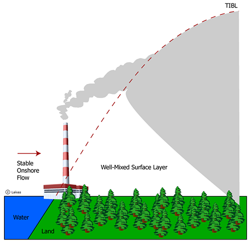
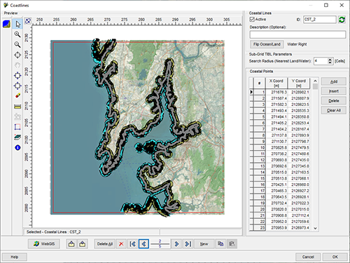
In order for the model to accurately depict the TIBL at a sub-grid scale (i.e., within a single grid cell), the user must define the line which divides the land and water surfaces. Accurate depiction of this coastline boundary is necessary since CALPUFF’s internal mechanism can only be run when the grid cell is over the appropriate land use (overland bordering water).


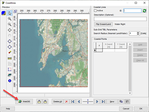
To support accurate coastline depictions, Lakes Software’s CALPUFF View includes the capability to download high-resolution coastline data via the WebGIS database. Data is derived from the Global Self-Consistent, Hierarchical, High-Resolution Geography Database (GSHHG) maintained by University of Hawai'i and the National Oceanic and Atmospheric Administration (NOAA).


The current version of CALPUFF View supports the latest available release of the GSHHG database – Version 2.3.7 – for projects utilizing the Version 7 & 7.3 CALPUFF modeling systems.


To download the data in your project, follow the steps below:


Step 1: Set up a CALPUFF View project or open an existing project.


Step 2: Open the Coastlines dialog via the CALPUFF menu.


Step 3: Click the WebGIS button to download the GSHHG data.


Modeling Tip picture


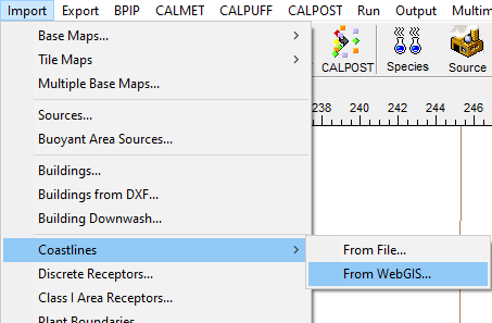
Note that this same process can be completed via the Import | Coastlines | From WebGIS menu option.


Modeling Tip picture


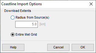
Step 4: Select the extents around which you want to import coastline data. Choose between a user-defined radius extending from all sources or over the entire meteorological grid.


Modeling Tip picture


Step 5: Visually verify the downloaded coastline. The line drawn in CALPUFF View will depict which side represents water (blue) and which side represents land (brown).


Note that you can have up to 10 separate coastlines in a project. For very complex lines, you may have to eliminate coasts drawn around small portions of land that would not induce fumigation effects.


Click OK when you are ready to proceed.


Modeling Tip picture


When the CALPUFF model is executed, the sub-grid TIBL processing routine will be automatically enabled.

Freeware

ENVIRONMENTAL NEWS ARTICLES

New Observations From ICESat-2 Show Remarkable Arctic Sea Ice Thinning in Just Three Years

March 11, 2022 - Over the past two decades, the Arctic has lost about one-third of its winter sea ice volume, largely due to a decline in sea ice that persists over several years, called multiyear ice, according to a new study. The study also found sea ice is likely thinner than previous estimates.


Read more →

February Capped Off a Warm, Dry Winter for U.S.

March 10, 2022 -February continued 2022’s relatively dry start, with the majority of the contiguous U.S. in drought. The end of the month also ushered in the end of meteorological winter, which ranked as the nation’s 12th-driest winter in 128 years.


Read more →

Additional Environmental News

Visit the Environmental News Network (ENN), the most dependable online environmental news source!


ENN

UPCOMING CONFERENCES

2022 Conference Schedule

Air & Waste Management Association’s 115th Annual Conference & Exhibition
June 27-30, 2022 | San Francisco, CA | Booth #304

Learn more →

LAKES SOFTWARE GROUP OF COMPANIES

Lakes Footer
Tauria Footer
ENN Footer

Lakes Logo
twitter   facebook   linkedin

1-170 Columbia St. W.
Waterloo, ON N2L 3L3

View Online

This newsletter contains information gleaned from various sources on the web, with complete links
to the sources cited. Organizations cited are in no way affiliated with Lakes Environmental Software.

For more information, please visit our web site at: www.webLakes.com.
All comments and suggestions are welcome.  You can e-mail us at: support@webLakes.com.
Privacy Policy