U.S. EPA Updates AERMOD Modeling System to 26135 |
 |
|
On July 9, 2026, the U.S. EPA published updates to the AERMOD Modeling System as version 26135. The updates include new versions of AERMOD, AERMET, AERMINUTE, AERPLOT, and AERSURFACE.
Details of the release and lists of important changes can be found in the release memorandum on the EPA website. Major changes include using multiple hourly emission files in a single AERMOD project, support for a new hourly surface data file format (GHCNh) in AERMET, refined surface roughness calculations in AERSURFACE, and more.
|
A full list of changes for each model or tool can be found on their respective web pages: AERMOD, AERMET, AERMINUTE and AERSURFACE. These updates immediately replace prior releases as the official regulatory versions of the applications.
Using the latest models is important for many reasons:
- Ensures calculations are performed according to current state-of-science algorithms.
- Keeps facilities in compliance by using approved model versions.
- Allows modelers to test and provide vital feedback on non-default model options that will shape the future of air modeling.
Lakes Environmental is hard at work on updates to AERMOD View and AERMET View to incorporate the new models and associated changes. Be on the lookout for email communications from Lakes Environmental announcing availability of the new AERMOD View and AERMET View releases.
If your copy of AERMOD View is no longer in maintenance, please contact our sales team at sales@webLakes.com for pricing to upgrade your license.
|
|
|
Online AERMOD Course – August 18-19, 2026 - Only a Few Spots Left! |
 |
Register today for our next available 2-day online AERMOD course taking place on August 18 and 19, 2026 from 8:30am to 5:00pm (Central Time – Chicago, USA).
Register today before space is gone!
Note: Due to the immense popularity of our online courses and small class sizes, we recommend registering and making payment as soon as possible to reserve your spot.
|
|
Online CALPUFF Course – September 29-30, 2026 |
 |
Enhance your air dispersion modeling skills by registering for our 2-day online CALPUFF course taking place on September 29 and 30, 2026 from 8:30am to 5:00pm (Central Time – Chicago).
Led by our expert instructors, this course offers in-depth instruction and hands-on exercises designed to help you effectively apply the CALPUFF modeling system in real-world scenarios.
Registration is now open – secure your spot today!
|
|
Just Announced – New Online AERMOD Courses! |
 |
We’re pleased to announce the following upcoming Online AERMOD Air Dispersion Modeling Courses. Join us for world-class training from our senior level air quality experts!
Online registration is available now. Our online courses sell out quickly! We recommend registering and making payment as soon as possible.
Don’t miss out, sign up today!
|
|
Lakes Environmental Closed for Ontario Civic Holiday |
Lakes Environmental's Waterloo office will be closed on Monday, August 3, 2026, to observe the Ontario Civic holiday. Our Dallas support office will remain open on this day. If you have any support needs during that time, please e-mail us at support@webLakes.com. Any sales inquiries will be responded to when our offices reopen on Tuesday, August 4, 2026.
|
|
UPCOMING TRAINING COURSES |
|

|
MODELING TIP |
New WebGIS Data: NASADEM |
|
WebGIS provides access to global geophysical data for air dispersion modeling, risk assessment, and other technical applications. Lakes Software’s commercial products – such as AERMOD View, CALPUFF View, and more – integrate WebGIS to automatically download terrain and land use data directly into projects.
This saves modelers time by reducing the need to locate, download, and prepare data from multiple external sources.
Beginning with AERMOD View Version 13.1, WebGIS now hosts a new terrain dataset: NASADEM.
NASADEM is a reprocessed version of elevation data collected by the Shuttle Radar Topography Mission (SRTM), which has long been available through WebGIS. Its updated processing incorporates improved geolocation and revised methods for filling gaps in the original data. NASADEM tiles provide the same geographic coverage and resolution (30 meters / 1 arc-second) as the existing SRTM1 Version 3 dataset in WebGIS, covering land areas between 60°N and 56°S latitude.
AERMOD View users with current maintenance can access NASADEM in the new Version 13.1 that was released earlier this month. Accessing NASADEM uses the same procedure as all WebGIS products:
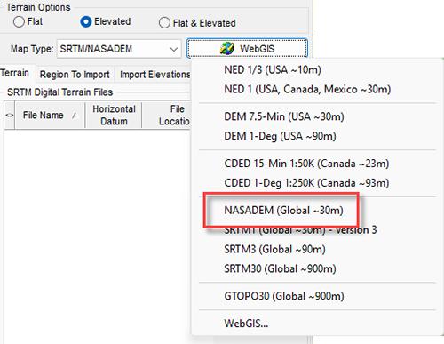
Step 1: Open AERMOD View’s Terrain Processor via the Terrain tool button

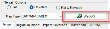
Step 2: Select SRTM/NASADEM as the Map Type
Step 3: Click the WebGIS button
Step 4: Choose NASADEM (Global ~30m) from the drop-down list
Support for NASADEM will be added to other Lakes products, including CALPUFF View and AERSCREEN View, in future updates.
|
|

|
ENVIRONMENTAL NEWS ARTICLES |
How an Influx of Salt May Affect Microbial Ecosystems |
July 20, 2026 - As sea levels rise and saltwater seeps into freshwater, stressed aquatic populations may retain overall growth even as diversity declines, MIT scientists find.
Read more → |
|
As "Super El Niño" Draws Global Attention, New Study Shows the Indian Ocean May Hold the Key to Mediterranean Climate Extremes |
July 13, 2026 - While the world watches the Pacific for signs of a possible "Super El Niño," new research suggests another tropical ocean may hold important clues to future climate extremes. .
Read more → |
|
|
|
LAKES SOFTWARE GROUP OF COMPANIES
|
 |
445 Wes Graham Way, Unit 203,
Waterloo, ON N2L 6R2
View Online
This newsletter contains information gleaned from various sources on the web, with complete links
to the sources cited. Organizations cited are in no way affiliated with Lakes Environmental Software.
For more information, please visit our web site at: www.webLakes.com.
All comments and suggestions are welcome. You can e-mail us at: support@webLakes.com.
Privacy Policy |
|
| | |