Lakes Environmental Software developed Char View for the U.S. EPA to allow modelers to prepare site data, emissions, inventories, and air models quickly while avoiding common human errors in the projects.
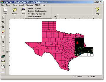
With Char View, modelers can import the most commonly available map formats: ArcView Shapefiles, USGS LULC and DLG, AutoCAD DXF, aerophotos, DOQs, and Bitmaps. Additionally, Char View preprocess site-specific terrain (DEM) data and meteorological (surface and upper air) data; preprocess and geo-correct source emissions data; set the Site Domain boundaries for the model, as well as annotate features with markers of various shapes, text and boxes; click and drag to measure distances between points; print views and export views.
Char View Characteristics
The GIS paradigm created in Char View has the following benefits:
Easy to use
Facilitate source geo-correction
Combined with Lakes Environmental developed Dataminer (an EPA tool) Char View can help organize emissions inventories, such as export data to various data formats (NEI, Excel, CSV, etc.)
Significant productivity gains over previously available inventory management and air modeling
Significant reduction in human error input
Makes very large projects feasible
Char View can achieve the above benefits, by providing the following features:
GIS-based spatial database functions
Generation of source specific meteorological data
Processing meteorological data using EPA recommended met-processors
Generating air model input files
Processing air models using EPA approved air models, such as AERMOD
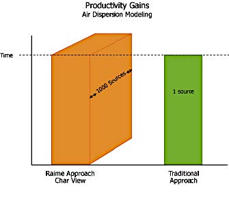
The graph to the right presents a real test case of Char View, on a large site in Texas, against traditional ways of conducting emissions inventory, preparing meteorological data, and running air models.
Char View real field study productivity gain over current traditional approach
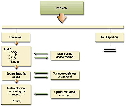
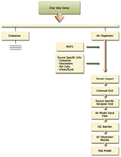
Char View’s extensive emissions inventory pre processing is depicted in the next flowchart. It can be observed in the flowchart that Emissions are tracked on a GIS interface which allows for geo-correction, spatial interpretation, post-processing, data manipulation, and export functions to other file formats (not shown).