AERMOD View
Gaussian Plume Air Dispersion Model
AERMOD View is Lakes Environmental’s intuitive interface for the U.S. EPA’s preferred air dispersion model, AERMOD. Designed to estimate pollutant concentrations from industrial sources, AERMOD accounts for terrain, building downwash, and meteorological conditions.
- Air permitting & compliance
- Environmental impact assessments
- Health risk analysis
- Regulatory reporting
Trusted by thousands of users across more than 100 countries, AERMOD View delivers robust tools and efficient workflows that empower consultants, regulators, and industry professionals to perform accurate, high-quality air dispersion modeling.
All-in-one Air Dispersion Modeling Software
Designed for Professionals. Trusted Worldwide.
Most commercial AERMOD software tools require add-ons or separate purchases for essential capabilities. With AERMOD View, your license includes:
AERMOD Parallel Processing
Accelerate your modeling projects with multi-core support for up to 8 processors, significantly reducing computation time—ideal for complex or large-scale studies.
Comprehensive Meteorological Preprocessing Tools (AERMET)
Save time and avoid the hassle of third-party tools. AERMOD View includes fully integrated AERMET utilities, making it easy to prepare site-specific meteorological data to U.S. EPA standards.
Tile Maps
Automatically access and download high-resolution geo-referenced map imagery—both satellite and street views—from global sources, allowing for accurate and intuitive visualization of modeling domains.
WebGIS Access
Seamlessly connect to online GIS services to import required geophysical data directly within AERMOD View, enhancing spatial context and improving project analysis and presentation.
See How We Compare
Discover how AERMOD View stands out from the competition with powerful features, intuitive design, and unmatched support - all in one comprehensive air dispersion modeling solution.
AERMOD Parallel (8 Processors)
AERMET Preprocessing Tools
Multi-Pollutant Modeling
Technical Support
Regulatory Updates
AERMOD View
Included
Included
Included
Included
Included
Competitors Software
Add-on required
Partial/Extra cost
May require additional tools
Included
Included
Using a Different AERMOD Interface?
Are you currently using a different AERMOD interface? Make the switch to AERMOD View today and experience the difference of a complete, fully supported modeling solution with no add-ons needed!
Smart Investment. Superior Value.
When evaluating dispersion modeling software, cost-of-ownership matters. AERMOD View provides:
- More features upfront – no expensive modules or plug-ins to purchase
- Lower annual maintenance costs – up to $85 US less than other solutions
- Continuous updates & expert support – included with annual maintenance
With AERMOD View, you know exactly what you’re getting. No hidden fees. Just a complete, professional solution at a competitive price.
Global Support. Regulatory Confidence.
Our team of scientists, software engineers, and a Certified Consulting Meteorologist (CCM) are industry leaders in environmental modeling. We ensure AERMOD View stays aligned with the latest U.S. EPA regulatory updates and best practices.
- Continuous software updates included with maintenance
- Access to world-class technical support and training resources
- Used and endorsed by environmental professionals across multiple sectors
AERMOD View Key Features
From 3D terrain visualization to building downwash and urban/rural classifications, AERMOD View provides intuitive tools that simplify your workflow—without compromising performance or compliance.
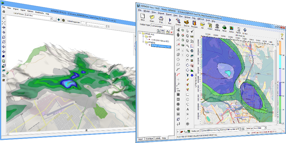
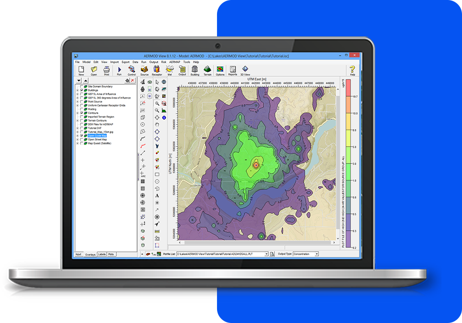
Integrated Interface
Fully integrated GIS-based interface combining easy to use graphical tools.
Google Earth Export
Export your buildings, sources, receptors and contours into Google Earth to share results with others.
Tile Maps
Automatically download and import high-resolution satellite and street map imagery into your projects.
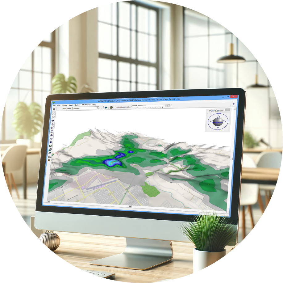
Terrain Data
Advanced terrain processing capabilities are offered for several terrain data file formats.
AERMOD MPI
AERMOD Parallel for up to 8 processors available at no additional cost.
3D Visualization
Comprehensive 3D visualization of your entire modeling area to meet all your modeling needs.
Empowering Air Quality Professionals with
an All-in-One Software Package
We’re here to make things easy! Here’s a list of everything included with your software purchase:
Software Updates
Technical Support and Resources
Popular Features
System Requirements
Our products are Microsoft Windows-based programs that can be installed in the following Windows operating systems:
- 32-bit and 64-bit Operating Systems
- Windows 10 or 11
Minimum Requirements:
- An Intel Pentium 4 processor (or equivalent) or higher
- At least 2 GB of available hard disk space
- 1 GB of RAM (2 GB recommended)
Met Data
Model Runs

Training
Custom IT Solutions

Advanced Technologies for Unique Solutions
Lakes Environmental provides a wide variety of software products in the areas of air dispersion modeling, human health and ecological risk assessment, emissions inventory, compliance, as well as emergency release.
- Advanced Air Pollutant Modeling
- Expert Health & Ecological Risk Analysis
- Comprehensive Emissions Reporting
- Rapid Environmental Emergency Mitigation
AERMOD View Software and Maintenance
AERMOD View
- 1 Year Access to Maintenance/Technical Support
- 1 Year Access to Software Updates
- Automatic Download of Tile Maps
- Automatic Download of NED Terrain Data
- User's Guides and Manuals
AERMOD View Maintenance
- Software Updates
- Technical Support
- Automatic Download of Tile Maps
- Automatic Download of NED Terrain Data
- User's Guides and Manuals
What our Clients are Saying About Us
I have started using CALRoads View and I am very impressed with the way it operates. It is user friendly and has the right tools – great product and customer service!
M.A. – NEW YORK, USA
Lakes’ automated quotation system and quick personalized responses to all queries, makes acquiring good quality meteorological data effortless. The support team is very helpful and always willing to assist promptly.
H.L - HALFWAY HOUSE, SOUTH AFRICA
Excellent instructor. Michael is clearly in his comfort zone when teaching a difficult subject. He incorporates just the right amount of levity, which adds to the enjoyment of the course.
M.C - SAN FRANCISCO, USA
Your software made modeling efforts easier. The contour plots and base maps were very nice. Importing DEM data was seamless. Your Tech Support team has been very helpful.
R.H - ANNAPOLIS, USA
I am really happy with the services and the level of professionalism from your staff members. The turnaround time is really good.